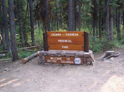
Akamina Kishinena Provincial Park

Provincial Park
Akamina Kishinena Provincial Park is located in the southeast corner of the province. Along with Waterton Lakes National Park and US Glacier National Park, this wilderness area preserves the Crown of the Continent, the narrowest point of the Rocky Mountains. High spacious alpine ridges, deep secluded valleys and windswept passes provide habitat and connectivity to the last self-sustaining grizzly bear population in the United States. Exposed alpine ridges, southern latitude and southern exposure provide winter range for goats and big horn sheep. The trails and passes of the Akamina-Kishinena used today to cross the axis of the continent, were established and used for many years by the early people’s and wildlife travelling between the Flathead Basin and the abundant Great Plains.
Fernie, Sparwood, Waterton
Akamina Pass Trail out of Waterton National Park
0
0
Bring your own drinking water, as potable water is not available in the park. To ensure that water from streams is safe to drink, it must be boiled for at least five minutes or treated/filtered.
A backcountry campground, with 10 wilderness sawdust tent pads, outhouse, and food cache is provided at Akamina Creek. This campground is located just off the main trail 0.9 km from Akamina Pass and 2.4 km from the Akamina Pass Trailhead. Register a trip itinerary with friends; check in and check out. Winter camping is available year-round at Akamina Creek sites. The BC Parks backcountry permit registration service allows you to purchase a backcountry camping permit before leaving home. Although this does not reserve a campsite, it provides the convenience of prepaying for your trip and not having to carry cash. We encourage all visitors to register online so we can reduce the need to collect fees in the field. This park only has pit toilets; no flush toilets. Fires in the developed area of the park are restricted to a communal fire ring in the Akamina Creek campground. Fires in the backcountry areas must be kept small, contained and a source of water to extinguish the fire must be readily available. Visitors must check with the Forest Service or at park trailheads to see if fires bans are in effect. To preserve vegetation and ground cover, please don’t gather firewood from the area around your campsite when staying in the developed area of the park. Dead wood is an important habitat element for many plants and animals and it adds organic matter to the soil. You can conserve firewood and air quality by keeping your campfire small. Limited burning hours or campfire bans may be implemented. Be prepared by bringing a portable stove for cooking.
If planning to horseback ride in the park, we recommend you read the Akamina Kishinena Horse Use Policy [PDF]. As horseback riders are required to obtain and carry with them a letter of permission from BC Parks please use our online form to generate/print your letter of permission, no less than seven days before entering the park. More specific information on using horses in the park can be obtained by contacting the Kootenay BC Parks office at 250 489-8540. There is no horse use allowed to Forum Lake, and riders travelling to Wall Lake must use the horse trail. Persons visiting Akamina-Kishinena Park are reminded that the park is a wilderness area without supplies or equipment of any kind. All arrangements for supplies and transportation must be made in advance.
Note: Also check under Upload/Download tab to see if there are more maps available. If the map below shows red lines, these indicate ridable trails which can be downloaded to your GPS (see Upload/Download tab)
From Hwy 3 turn south at Pincher Creek onto Hwy 6. It is 48km to Waterton Lakes National Park. From the park gate access the Cameron Lake park road to reach the Akamina Pass trailhead (16 km). A 30 minute, 1.5 km uphill walk reaches the boundary between Alberta and BC and the eastern border of Akamina-Kishinena Provincial Park. The closest communities are Waterton Lakes National Park community and Sparwood.

Legend

Required
Your email address will not be displayed. This is only so we may contact you if we need to clarify something in your comment.
Required
Required
Required
Note: All of our Geo-Referenced PDF maps are available for free from the Avenza from the Map Store. These maps can be used with the Avenza Maps app on GPS enabled Smartphones and tablets.

GPX Upload
Rode this trail? Show the HCBC Trail Community Which Route You Ride

HCBC monitors the integrity of the GPX files uploaded prior to posting on this website. We will contact you via your email if your track is suitable for an Avenza Map.

Name:

Email:

Please upload GPX files only.


Image Upload
Saw Something Cool? Share it with the HCBC Trail Community

HCBC monitors the integrity of all images and comments posted on this website. Please allow us 24 hours to review the Images uploaded for this trail before they appear on our website. Thank you

Please upload jpeg images only.