Old Glory Trail

Other
Horses are allowed on the Old Glory Trail north of Rossland. There is a BC Forest Service trail that leads to the lookout at the summit of Old Glory Mountain.
Kootenays, Rossland
Plewman Trail
10 km and 8 km
49.153694
-117.858481
The Old Glory Trail (6 miles/10 km) follows Unnecessary Ridge and also leads to the summit. The shorter Plewman Trail (5 miles/8 km) goes through the Plewman Basin. The two trails share a common trailhead on Hwy 3A east of Nancy Greene Provincial Park towards Rossland. The highway makes a big bend as it leads past Hannah Creek. Watch for the pullout and trailhead on the west side of the highway, about 100 yards (91 m) south of Hannah Creek. The trail divides a short distance from the trailhead, with Plewman Trail to the right and Old Glory to the left. This area was used in times past by the Colville Indians from Washington state, who made regular trips here to pick huckleberries. Local place names such as Squaw Basin, Indian Flats, and Papoose Basin reflect this history. The former Forest Service lookout on Old Glory Mountain, the remains of a meteorological station, some stables, and the Old Glory Trail are remnants of the area's more recent history. For more information see the Kootenay-Columbia Trail Society website at: http://www.rosslandtrails.ca
Note: Also check under Upload/Download tab to see if there are more maps available. If the map below shows red lines, these indicate ridable trails which can be downloaded to your GPS (see Upload/Download tab)
trailhead on Hwy 3A east of Nancy Greene Provincial Park towards Rossland. The highway makes a big bend as it leads past Hannah Creek. Watch for the pullout and trailhead on the west side of the highway, about 100 yards (91 m) south of Hannah Creek. The trail divides a short distance from the trailhead, with Plewman Trail to the right and Old Glory to the left.

Legend

Brent Wray

Rossland Range posted on: 02 / 24 / 2023

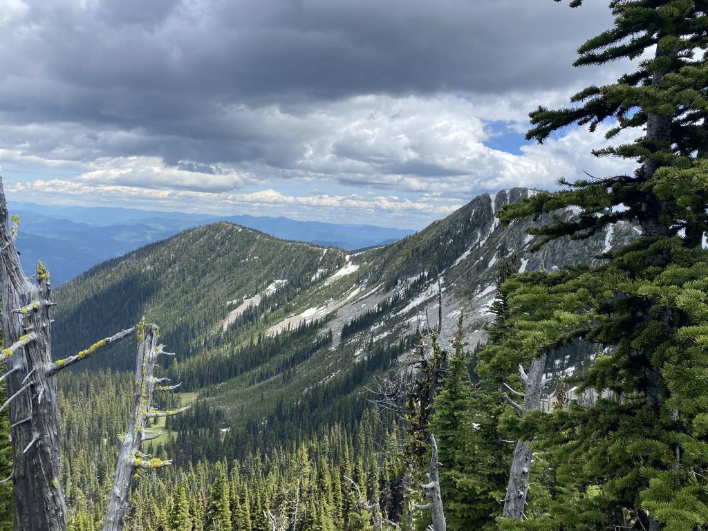
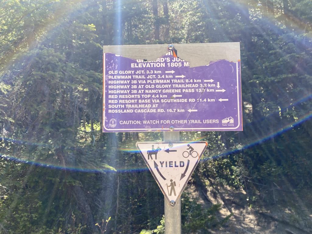
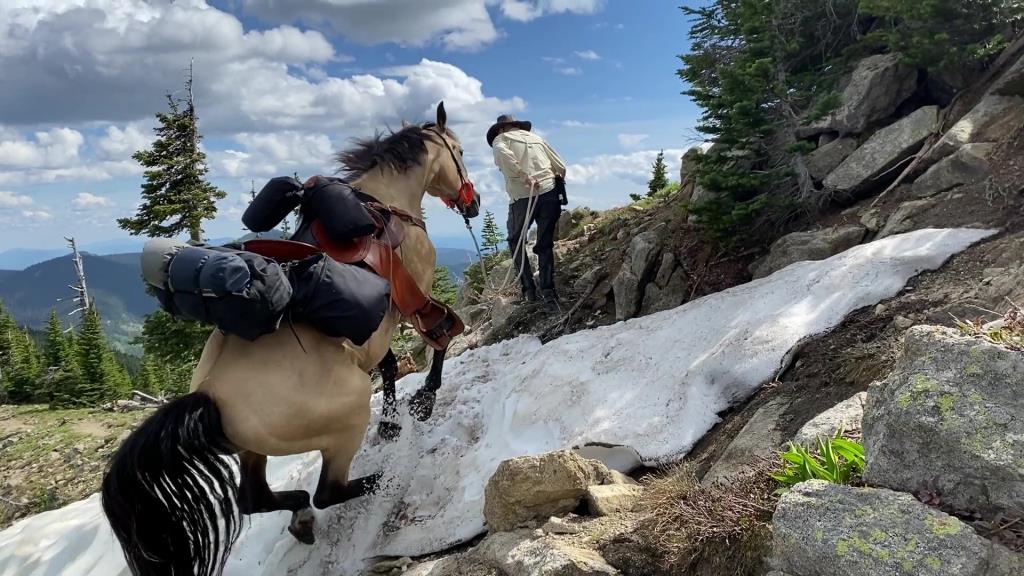
This area is more appropriately named Rossland Range. Old Glory is just one of the trails. Seven Summits, Old Glory, Plewman and Dewdney are the main trails. Seven Summits and Dewdney are very popular mountain biking destinations, so be aware! Also, to ensure good mountain biker / equestrian relations, please kick horse manure off the trail. Nothing upsets a mountain biker more than having their sweet, flowy downhill interrupted by a fresh & steamy horse manure facial. These are challenging trails with 600m to 1000m elevation gain, bridges to cross (Plewman & Old Glory), and rocky, technical terrain.


Required
Your email address will not be displayed. This is only so we may contact you if we need to clarify something in your comment.
Required
Required
Required
Note: All of our Geo-Referenced PDF maps are available for free from the Avenza from the Map Store. These maps can be used with the Avenza Maps app on GPS enabled Smartphones and tablets.

GPX Upload
Rode this trail? Show the HCBC Trail Community Which Route You Ride

HCBC monitors the integrity of the GPX files uploaded prior to posting on this website. We will contact you via your email if your track is suitable for an Avenza Map.

Name:

Email:

Please upload GPX files only.


Image Upload
Saw Something Cool? Share it with the HCBC Trail Community

HCBC monitors the integrity of all images and comments posted on this website. Please allow us 24 hours to review the Images uploaded for this trail before they appear on our website. Thank you

Please upload jpeg images only.

Additional files to Download

Geo-Ref maps for Avenza Maps App on mobile devices

Note: If you are on a computer, you can print these maps. If you using a mobile device, then these maps are available to download from the Avenza Map Store within the Avenza app.