Grace Road Trails - North Cowichan Forest Lands Located in the Vancouver Island-Central Coast
Grace Road Trails - North Cowichan Forest Lands
Legend
Grace Road Trails - North Cowichan Forest Lands Comments Want To Get Involved? Post Comment
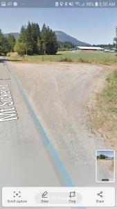
parking on mount sicker road posted on: 01 / 31 / 2019
The parking mentioned and shown above is NOT public parking. It is PRIVATE land owned by the farmer whose field you can see in the background. The farmer has given the SVI members permission to park there provided we are responsible for our own actions but it is important to note that this parking is not open to the general public unless permission is given by the landowner.
Grace Road parking posted on: 10 / 19 / 2018
It is important to note that the parking area noted as 20 feet past the Grace Road gate is privately owned land and the owners also own the large hay field next to it. the BCHBC ought to get permission to use the parking area from the owners in writing. Some individual members of the SVI have obtained permission to park at that parking spot but it is not public land. Important to know for liability issues.
GPX Upload
Rode this trail? Show the HCBC Trail Community Which Route You Ride
HCBC monitors the integrity of the GPX files uploaded prior to posting on this website. We will contact you via your email if your track is suitable for an Avenza Map.
Name:
Email:
Image Upload
Saw Something Cool? Share it with the HCBC Trail Community
HCBC monitors the integrity of all images and comments posted on this website. Please allow us 24 hours to review the Images uploaded for this trail before they appear on our website. Thank you
 HCBC
HCBC


