Moose River Route - Robson Park

Back Country Trail
The Moose River Route is a main arterial route to access the many trails along the Continental Divide. The Moose route travels through rugged but very scenic high-country. It takes work to get there but you won't be disappointed. The Route is recommended for experienced back country riders. You will cross the Continental Divide (BC/Alberta border) many times. At the 49 km mark, Moose Pass Route will enter into Jasper National Park. Grazing and camping permits are required for all backcountry camping in Jasper Park, carry your permit with you. The Moose River Route is just that, a route, not specifically a trail. This is not to imply that there is no visible trail but that there are a number of sections that cross braided gravel flats, or avoid marsh areas and may not be discernible. The Moose Valley experienced two major fires 20 years ago and there are many burned standing trees which continue to fall and old way finding blazes may not be visible. Be prepared as major tree clearing may be required. Back Country Horsemen - Robson Valley chapter has a Partnership Agreement with BC Parks for this area. Contact the Chapter for updated trail conditions.
McBride, Jasper and Valemont
Continental Divide, Colonel Creek Trail, Upright Creek Trail, Jasper North Boundary Trail
65 km
950 m
52.92311
-118.79842
The trail follows the Moose River and campsites are situated along creeks
Staging area is at the Moose River Gravel Pit off Highway 16. Corrals and hitching rails available. No stock water available. See Directions.Camping at the staging area is permitted for overnight. when leaving on the trail the next morning. Best to advise the Robson Park Rangers your vehicle will be parked there as they will try to do a drive through once a day.
Backcountry camping is free in Mount Robson Park. You can self register at the Staging area kiosk. There are several primitive back country camps along the Moose River Route located a day or less ride apart. From the Moose Staging area to Slide Lake by Moose Pass are the following camps: Resplendent Creek camp 15.3 km, Hi-Huna Camp, Trio Mountain camp 26 km, High-water Camp,(opposite side of Moose River from Trio Camp), Steppe Creek Camp, 38 km, Slide Lake Camp, 43 km, Calumet Creek Camp (Jasper), 52 km, Adophus Camp (Jasper), 61.5 km. Jasper National Park backcountry equine camping and grazing permits are required for any overnight camping in Jasper. Purchase Jasper permits prior to your trip and carry with you.
There are many multi-day/multi-week trip options once you enter the Moose Valley. If you enter into Jasper National Park and camp you will require a permit ahead of time. 1) Colonel Creek trail and Upright Creek Trail in Robson Park are accessed from where the creeks empty into the Moose River. Colonel and Upright camps are located 3 to 4 hour ride up each of those creeks, located just over the border into Jasper. Moose River is the common access to these 2 shorter trail options. 2) 4 to 5 day (one way) trip along the Moose River Route into Jasper to the Calumet and Adophus camps (Jasper permits required) Take a day trip over to Berg Lake from Adophus camp, well worth it!. Horses are not permitted on the Berg Lake trail past the Berg Lake campground to Highway 16. 3) 3 to 5 day (one day) trip travel down the Smoky river (Jasper North Boundary Trail) to Chown Creek and over Bess Pass crossing back over into BC and onto Blueberry trailhead and back to McBride. (km 42 on Holmes River FSR McBride) 4) 10 to 14 days travel down the North Boundary Trail to Celestine Road in Jasper or Rock Lake. Depending on weather and spring run-off, the numerous unbridged river crossings can present a legitimate hazard. Late summer into early fall seem to offer the most reliable water levels, however creek and river levels can rise quickly after periods of heavy rain. (Contact [email protected] to check with the Robson Valley Chapter for a current trail report).
Note: Also check under Files Maps Upload/Download tab to see if there are more maps available. If the map below shows red lines, these indicate ridable trails which can be downloaded to your GPS (see Files Maps Upload/Download tab)
Staging area at the Moose River Gravel Pit off Highway 16 just east of Moose Lake in Mount Robson Park (Look for highway signs). Turn north onto the gravel approach and cross the railroad tracks at own risk. Check the gate lock and proceed with caution to the staging area approx 1/2 km up the road.

Legend

Eileen MacDonald

trail clearing update posted on: 11 / 18 / 2024

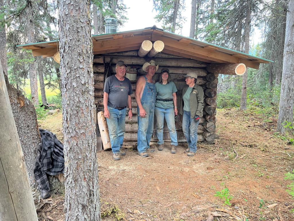
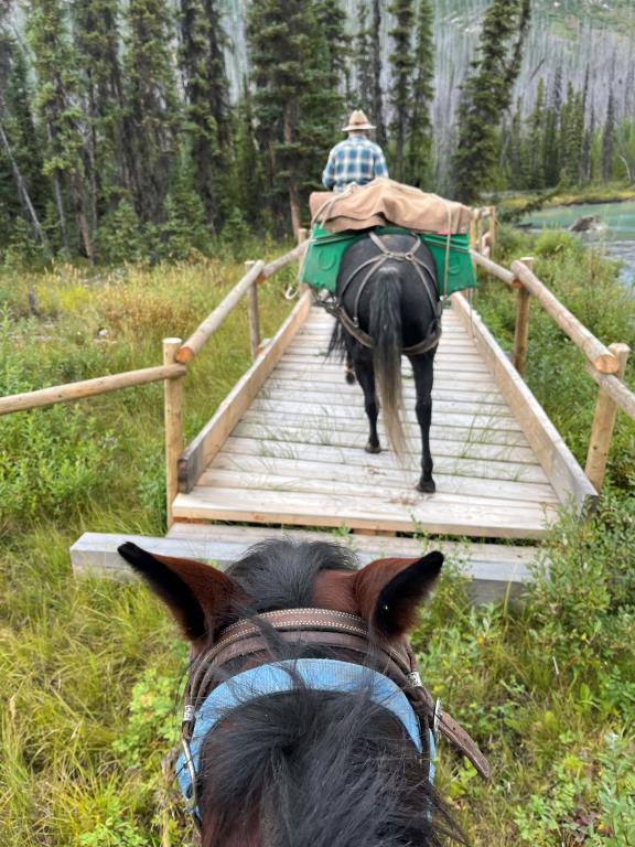
In May 2024, the Arctomys creek bridge span was lengthened to allow horses to enter and exit safely onto more solid ground. In the September 2024, The Robson Valley Chapter cleared the trail from the Moose River staging area to Hi-Huna camp and then from Resplendant Creek to just up river of Artomys creek bridge on the Moose River. In sections where the trail was being undermined by the creek/river the trail was rerouted onto more solid ground. In September 2024, the Resplendant creek trappers cabin was straightened and a new tin roof installed and a new wood stove/chimney installed.


Required
Your email address will not be displayed. This is only so we may contact you if we need to clarify something in your comment.
Required
Required
Required
Note: All of our Geo-Referenced PDF maps are available for free from the Avenza from the Map Store. These maps can be used with the Avenza Maps app on GPS enabled Smartphones and tablets.

GPX Upload
Rode this trail? Show the HCBC Trail Community Which Route You Ride

HCBC monitors the integrity of the GPX files uploaded prior to posting on this website. We will contact you via your email if your track is suitable for an Avenza Map.

Name:

Email:

Please upload GPX files only.


Image Upload
Saw Something Cool? Share it with the HCBC Trail Community

HCBC monitors the integrity of all images and comments posted on this website. Please allow us 24 hours to review the Images uploaded for this trail before they appear on our website. Thank you

Please upload jpeg images only.